New Feature:Now earn badges with a free CT Trail Finder account!

Campbell's Peaceful Valley Conservation Area

Campbell's Peaceful Valley Conservation Area has a network of trails that go through a wooded area with unique rock outcroppings.
Trail Activity
Hiking Walking Bicycling
Length
2.1 miles, Network
Difficulty
Easy
Town
Tolland
Surface
Packed Earth/Dirt, Rock/Ledge, Grass
Pets
Permitted on leash
Fees
No

Description

This 70-acre property was purchased in 2003 from Beatrice and Clarence Campbell with assistance from a state DEEP grant. It contains woodland areas, open pasture, wet alder shrub lowlands as well as a brook. The lowlands rise steeply about 150 feet to a ridge line of exposed ledge at an elevation of 850 feet above sea level.

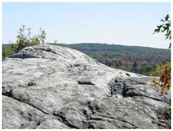
The ridge line with several high outcrops offers scenic views of the surrounding valley and hillsides. The marked trails include the yellow loop trail, with a steep climb to an overlook of Shenipsit Lake, the blue loop trail which crosses the brook and meanders along the top of a ridge, and a red trail leading through the bird-filled meadow. Trails connect to the Stoppleworth Conservation Area (white trail) just to the north and the Knofla Conservation Area to the south across Hunter Road.

Other Information

Rules

  • Leave no trace.
  • Stay on marked trails and roads.
  • Do not disturb vegetation or wildlife.
  • No littering - carry out what you carry in.
  • No fires.
  • No hunting or firearms allowed.
  • Respect the rights of other visitors.
  • No motorized vehicles.
  • No horseback riding.

Notify the Conservation Commission if you see any violations.

Trail Manager

Town of Tolland Conservation Commission
21 Tolland Green
Tolland, CT 06084
860-871-3601
View website

Trail Tips

Travel and Camp on Durable Surfaces
Stick to established trails and campsites. If there's no trail, try to walk on rock, gravel, or snow and spread out so that your group doesn't create a trail.
Legend
Hide All

Trailhead Information

From the Tolland Green

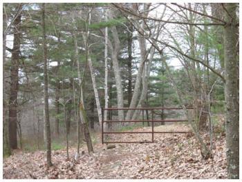
Head onto CT-195 North/74 West. After a few miles take a right onto Burbank Road. Then shortly take another right onto Peter Green Road. At the end of the Peter Green Road, stay to the right. Continue north on Hunter Road for another mile, and the entrance will be on the left.

From points north

Take Route 140 to Crystal Lake. Turn south on South Road and continue on Hunter Road (1.4 miles from Route 140), and the trail entrance will be on the right. 

Click on a parking icon to get custom directions
Please Log In or Create Account to add comments.
Add a Service
Find businesses and organizations that are located around this trail that support adventuring outdoors!
Legend
Hide All
Hide All
No services shown. Try zooming out.
Hang Tight!
Nearby services are loading
SHARE THIS TRAIL
PRINT THIS TRAIL

Add Trail Log

Please wait…
Join In on the Fun!
Log in or create an account below to unlock all the great features of Connecticut Trail Finder: keep track of trails you want to do, preserve memories of trails you’ve done, and more!
Your log in attempt was not successful. Please try again.
    Lost your password? Reset your password
    Don't yet have an account?
    There was an issue with your submission. Please try again.
      * Indicates required field
      Already have an account? Login here
      Enter your username, and we will send you a new, randomly generated password to your email account.
      There was an issue with your submission. Please try again.

        Success! A new password has been emailed to you.

        Log in now

        Please wait…