Over 2500 miles of trails on CT Trail Finder, with more on the way!

Palmer Kendall Mountain Conservation Area

The Palmer Kendall Mountain Conservation Area is a woodland area with steep terrain and contains Kendall Mountain, the third highest point in Tolland. 
Trail Activity
Hiking Walking
Length
1.9 miles, Network
Difficulty
Moderate
Town
Tolland
Surface
Packed Earth/Dirt, Rock/Ledge
Pets
Permitted on leash
Fees
No

Description

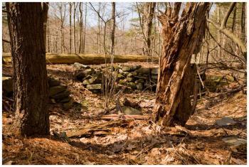
The Palmer Kendall Mountain Conservation Area is a 74-acre parcel of land on the north side of Kendall Mt. Road in the north-central section of Tolland. 

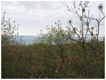
The property is in the headwaters to the Skungamaug River and has unique geological features with sweeping views from the top of Kendall Mountain. These features, along with a winding brook and dense mountain laurel thickets, provide an enticing backdrop for hiking and snowshoeing.

This property is located in proximity to other conservation areas including Crystal Peat, Schindler-Schmidt, Knofla, Campbell's Peaceful Valley, and Stoppleworth.

Other Information

Rules

  • Leave no trace.
  • No littering - carry out what you carry in.
  • Visitors stay on marked trails.
  • No horseback riding.
  • No mountain biking.
  • Do not disturb wildlife.
  • No hunting or firearms.
  • No fires.
  • Area closed from sunset to sunrise.
  • Notify the Conservation Commission of organized group activities.

See more information from Tolland's Conservation Commission.

Trail Manager

Town of Tolland Conservation Commission
21 Tolland Green
Tolland, CT 06084
860-871-3601
View website

Trail Tips

Respect Wildlife
Avoid unwanted animal guests: store your food and trash securely and keep your camp clean of crumbs and spills.
Legend
Hide All

Trailhead Information

From the north (Crystal Lake, or from Route 140)

Take South Road and then a left turn onto Lord Road, which turns into Sugar Hill Road. At the three-way intersection, take a sharp left onto Kendall Mountain Road, trailhead will be on your left just past the Skungamaug River.

From the south (Tolland Center, or from Route 195)

Take Old Stafford Road north and either turn left onto Sugar Hill Road and then right onto Mount Kendall Road - trailhead will be on your left just past the Skungamaug River - or stay on Old Stafford Road and then turn left onto Cook Road - trailhead is on your right just past the entrance to Crystal Peat Conservation Area/Wildwood Road.

Click on a parking icon to get custom directions
Please Log In or Create Account to add comments.
Add a Service
Find businesses and organizations that are located around this trail that support adventuring outdoors!
Legend
Hide All
Hide All
No services shown. Try zooming out.
Hang Tight!
Nearby services are loading
SHARE THIS TRAIL
PRINT THIS TRAIL

Add Trail Log

Please wait…
Join In on the Fun!
Log in or create an account below to unlock all the great features of Connecticut Trail Finder: keep track of trails you want to do, preserve memories of trails you’ve done, and more!
Your log in attempt was not successful. Please try again.
    Lost your password? Reset your password
    Don't yet have an account?
    There was an issue with your submission. Please try again.
      * Indicates required field
      Already have an account? Login here
      Enter your username, and we will send you a new, randomly generated password to your email account.
      There was an issue with your submission. Please try again.

        Success! A new password has been emailed to you.

        Log in now

        Please wait…